演習内容:
この演習4で最終的に得られる画像
|
演習内容: |
この演習4で最終的に得られる画像
|
GRASS起動後にWindow右下の「Projection values」をクリック
LOCATION:  latlon2
MAPSET:    PERMANENT
DATABASE:  /home/student

と入力したら、Escを押しながらEnter
Please specify the coordinate system for location <utm>

A   x,y
B   Latitude-Longitude
C   UTM
D   Other Projection
RETURN to cancel

>B
Do you wish to specify a geodetic datum for this location? (y/n) [y] y

Please specify datum name
Enter 'list' for the list of available datums
or 'custom' if you wish to enter custom parameters
Hit RETURN to cancel request

>list

(種々の測地系が表示される)
Short Name  Long Name / Description

(中略)
tokyo   Tokyo       (bessl ellipsoid)
wgs72   WGS_1972    (wgs72 ellipsoid)
wgs84   WGS_1984    (wgs84 ellipsoid)

Please specify datum name
Enter 'list' for the list of available datums
or 'custom' if you wish to enter custom parameters
Hit RETURN to cancel request

>wgs84

Now select Datum Transformation Parameters
Please think carefully about the area covered by your data
and the accuracy you require before making your selection.

Enter 'list' to see the list of available Parameter sets
Enter the corresponding number, or <RETURN> to cancel request

>list

Number Details
---
1    Used in whole wgs84 region
     (PROJ.4 Params towgs84=0.000,0.000,0.000)
     Default 3-Parameter Transformation (May not be optimum for older datums;
 use this only if no more appropriate options are available.)
---

(中略)

>1


                  DEFINE THE DEFAULT REGION


             ====== DEFAULT REGION ======
             | NORTH EDGE: 15          |
             |                          |
  WEST EDGE  |                          |EAST EDGE
  102    |                          |108
             | SOUTH EDGE: 10          |
             ============================

  PROJECTION: 3 (Latitude-Longitude)      ZONE: 0

                    GRID RESOLUTION
                        East-West:     0.00429
                      North-South:     0.00429


と入力した後で、Escを押しながらEnter
→ GRASSのWindowが起動する
| [/home/student/data/modis内の画像] |
|
※Windowsのエクスプローラーを使っても、あるいはCygwinのWindow内でコマンドで指定しても可能
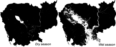
等緯経度座標系のMODISデータから算出した植生指数(EVI)と水指数(NDWI)画像を使用して演習を行う。
> cd /home/student/latlon2/PERMANENT
> r.in.gdal input=2003-2004evi_cambodia.tif  output=evi
> r.in.gdal input=2003-2004ndwi_cambodia.tif  output=ndwi
> d.mon x0
> d.rast evi.red

> r.colors map=evi.red rules=evi(EVIのカラーテーブルの読込)
> d.rast evi.red
> r.in.gdal input=2003-2004evi_cambodia.tif  output=evi
> r.in.gdal input=2003-2004ndwi_cambodia.tif  output=ndwi
> g.region w=102 e=108 n=15 s=10 res=0.00429
> r.mapcalc "water1=if(evi.red==0, 0, ndwi.red>=evi.red, 1)"
               ・
               ・
               ・
> r.mapcalc "water46=if(evi.46==0, 0, ndwi.46>=evi.46, 1)"
> r.stats -c input=water1
        ・
        ・
        ・
> r.stats -c input=water46

(アウトプットの例)

0 1231368   ← 「0」:水域以外,「131368」:画素数
1 16206    ← 「1」:水域,「16206」:画素数
* 383660
> d.mon x0
> d.rast water??  ← 最小水域面積画像
> d.mon x1
> d.rast water??? ← 最大水域面積画像